 Dane Carlson and I have been hashing out ideas for the next moves in La Prusia's public
realm (within EH&D #2.) We know that stitching activity and program into the very linear site together (especially from
side-to-side (east to west)) is going to be tricky. We also know that people are
determined to own their own piece of the site and are interested in maintaining a productive central corridor. The question will remain, who owns the space? In the image above, the edges of the central path (in red) are thought to be places that anticipate activity and social exchange. A kid should be able to kick a soccer ball all the way through the site, using these types of spaces to develop a sense of growing public ownership. One day he or she can run a business along the shaded edges of these small civic spaces.
Dane Carlson and I have been hashing out ideas for the next moves in La Prusia's public
realm (within EH&D #2.) We know that stitching activity and program into the very linear site together (especially from
side-to-side (east to west)) is going to be tricky. We also know that people are
determined to own their own piece of the site and are interested in maintaining a productive central corridor. The question will remain, who owns the space? In the image above, the edges of the central path (in red) are thought to be places that anticipate activity and social exchange. A kid should be able to kick a soccer ball all the way through the site, using these types of spaces to develop a sense of growing public ownership. One day he or she can run a business along the shaded edges of these small civic spaces.
 |
|
 As the land on EH&D #2 is developed to accommodate high density housing over time, the central corridor will become more and more lively and integrated with a host of productive uses. The tree canopy overhead that frames the site provides fruit to be harvested and sold, grasses, wood and metal products are made into useful tools to build more homes and prepare nutritious food for the community. The image above highlights pixilated zones of active use, be they commercial selling points, places for physical manufacturing or other small scale production, or the intimate community gathering spaces that are threaded into the public realm. The conceptual idea remains that these "zones" are not single purpose or inflexible in any way, but rather can adapt to suit emerging micro-economic and sociopolitical needs.
 |
|

 |
| What appears to be a single line running through the site is more akin to a gradient of public and private function. It is not a road for automobiles. It is not a bike lane. It is not a sidewalk. Nor is it a greenway or any other single environmental use or monocultural element. It is a critical organizing agent across the length of the site. It needs to operate as an organic vein that has the potential to move people, goods and services, but more importantly than fitting directly into a foreign imperial paradigm, the "line" is able to flex between productive vegetation and swell where housing turns to micro-economic uses, acting as a kind of suture that will tie a divided physical rift back to it's whole. | | | | |
 |
| As illustrated by the isometric diagram above, the "path" is an intermediate collection of cross-sectional spaces that vary in thickness, threaded through the sacred trees and offering site scale adaptation based on shifting needs over time. |


As we continue to think about and accommodate the forces that are shaping the public spaces through the site, it is becoming less clear how to represent this temporal "flexibility" graphically. Not simply the idea of an elastic, vague framework that things will be inserted into, but as a collection of activities that can be augmented as they negotiate their resources and boundaries. As the functional uses of what are effectively "people's front yards" become more and more pixilated over time, and as those spaces swell or contract or shift over to expand a successful endeavor, the image will change accordingly. In a very real way, the design of the site is not being physicalized as clearly as say, the footprints of a house, with easily understood boundaries, but rather through informal negotiations between individuals and small social clusters, acting as accountable curators of social, political and economic engines.
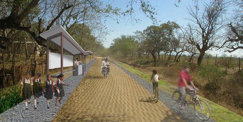
 Dane Carlson and I have been hashing out ideas for the next moves in La Prusia's public
realm (within EH&D #2.) We know that stitching activity and program into the very linear site together (especially from
side-to-side (east to west)) is going to be tricky. We also know that people are
determined to own their own piece of the site and are interested in maintaining a productive central corridor. The question will remain, who owns the space? In the image above, the edges of the central path (in red) are thought to be places that anticipate activity and social exchange. A kid should be able to kick a soccer ball all the way through the site, using these types of spaces to develop a sense of growing public ownership. One day he or she can run a business along the shaded edges of these small civic spaces.
Dane Carlson and I have been hashing out ideas for the next moves in La Prusia's public
realm (within EH&D #2.) We know that stitching activity and program into the very linear site together (especially from
side-to-side (east to west)) is going to be tricky. We also know that people are
determined to own their own piece of the site and are interested in maintaining a productive central corridor. The question will remain, who owns the space? In the image above, the edges of the central path (in red) are thought to be places that anticipate activity and social exchange. A kid should be able to kick a soccer ball all the way through the site, using these types of spaces to develop a sense of growing public ownership. One day he or she can run a business along the shaded edges of these small civic spaces. 


No comments:
Post a Comment